


HERRGARDSKLING : FORTIFIED HILL-SITE ON GOTLAND
In this article, the author argues that the Gotlandic hilltop complex, Herrgårdsklint,
should be viewed as a fortiied hill-site (Sw. befäst höjdbosättning). This phenomenon
occured mainly on the East Middle Swedish mainland, where the fortiied hill-sites were
constructed by the late Early Iron Age period (AD 0–550) élite. The complex comprises
a 120 metre long and 2.5 metres high dry-stone wall of limestone built on a large cliff
and encloses an area of c. 1.5 ha, in which several signiicant house foundations of
limestone are visible even today. It was once given the antiquarian designation “clifffort”
(Sw. klintborg), a term which has contributed to a rather simplistic approach
from scholars. In past archaeological research, Herrgårdsklint, with the rest of the
constructions categorized as cliff-forts, has often been seen merely as a “temporary
refuge in times of unrest.” This perception has been challenged, however, by a new
approach that puts Herrgårdsklint in the spotlight of eastern Gotland during the Roman
Iron Age/Migration Period. A recently initiated project, which aims to remedy the weak
empirical situation regarding the diverse Gotlandic cliff-forts, has carried out new
analyses of the pottery and animal bone material found in a 1940s excavation of a
couple of the house foundations. Together with the observation of the architecturally
advanced stone wall’s entrance construction (which the author suggests is an imitation
of a clavicula-entrance of a sort used by the Imperial Roman army), the results indicate
that Herrgårdsklint should be viewed as a strongly fortiied permanent/semi-permanent
settlement, which controlled a large hinterland that specialized in beef production and
shows signs of close connections to R oman ideas.
288 Runsa Borg – Representative Life on a Migration Period Hilltop Site
Herrgårdsklint revisited: a fortiied hill-site on Gotland
Introduction
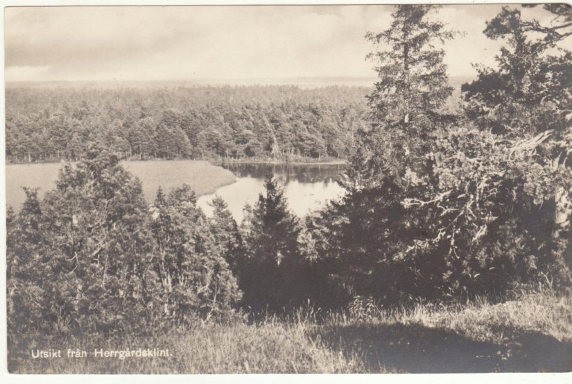
Situated on a remote clif in the eastern part of
the Baltic island of Gotland, a hilltop complex
built sometime during the late Early Iron Age
(AD 0–550) commands a view over what is
today a great woodland territory (ig. 2). An area
of c. 1.5 ha is enclosed by vertical precipices up
to 15 metres steep in the north, east and west,
as well as a 120 metre-long and 2.5 metre-high
transverse dry-stone wall in the south (igs. 1 and
8). Within this area, the remains of a number
of substantial stone-house foundations, similar
to those of the late Early Iron Age landscapes
of the rest of Gotland and the adjacent island,
Öland, are visible even today. his complex
is known as Herrgårdsklint (en. Clif of the
manor) and was once given the antiquarian
designation “clif-fort” (Sw. klintborg), a term
which will be shown to be anything but simple,
and seems to have been somewhat forgotten by
archaeologists. he following article is based
on results obtained from a recently initiated
archaeological project1, the aim of which is to
remedy the weak empirical situation and create
a more nuanced image of the diverse Gotlandic
clif-forts2. Below, I will argue that there
are several indications that Herrgårdsklint
might constitute a fortiied hill-site (Sw. befäst
höjdbosättning); a phenomenon that has
recently attracted archaeological attention,
formerly being mainly known, in Scandinavian
research, on the East Middle Swedish mainland.
If so, this hilltop complex would have been
central to the Gotlandic Early Iron Age élite.
Before a discussion of Herrgårdsklint in the
centuries following A.D. can begin, however, a
brief review of past research focuses within the
discourse, as well as a study of the terminology,
is necessary.

To deconstruct a cliff-fort
Traditionally, Gotland’s hill-forts have
been divided into three subgroups; clifforts
(Sw. klintborgar), lat ground-forts (Sw.
latmarksborgar) and bog-forts (Sw. myrborgar)
(Stenberger 1940a: 66). he irst subgroup
consists of remains which can be described as
the general idea of how a hill-fort is supposed
to be; great stone walls erected on an elevated
position which together completely enclose
an area (e.g. Torsburgen). But such an old
term also conceals constructions which are
made up of nothing more than a single row
of stones which seems to encircle a clif or a
hilltop in an almost symbolic way (e.g. Lärbro
RAÄ 17). Since few of the Gotlandic hill-forts
have been archaeologically excavated, the idea
that topographic and geographic location is
synonymous with function and dating has been
popular in modern archaeological research
(e.g. Cassel 1998, 2008). Furthermore, the
sheer absence of clif-forts afected by large
contract archaeological projects, usually the
result of the often extensive empirical data
associated with the types of investigations that
also serve as a catalyst for continued research
interest (Olausson 1995), simply do not exist.
his lack of empirical data might be one
factor contributing to why traditional ideas
concerning the clif-forts have been, for the
most part, unchallenged.
here have been two main ields of research
interest within the discourse. For the majority
of the 1900s, interpretations of the so-called
forts were dominated by expositions
of military strategies and various sorts of
fortiication, as a rule often combined with
accounts of the supposed unrest during
Roman Iron Age/Migration Period (e.g.
Nihlén and Boëthius 1933, Stenberger 1945;
1964, Lundström 1955, Manneke 1979,
Engström 1984). It was not until the 1990s
and early 2000s, as postmodern theories
began to inluence archaeological studies, that
alternative interpretations started to dispute the
“clif-fort as strictly a fort” paradigm. Instead
of accentuating the military aspects of the
constructions, they came to advocate an
understanding based on more symbolic
premises of the monuments. hus, the mental
and ritual nature of the clif-forts became the
focal point (e.g. Cassel 1998, 2008; Hegardt
1991a, 1991b; Swedish mainland material: see
Johansen 1997, Carlsson 2001, 2005, Wall
2003). Although these studies can be described
as a breath of fresh air in a ield of research
which, with few exceptions (e.g. Olausson
1995), can be described as stagnant for quite
some time, they had a tendency to theorize
outside the framework of the empirical data,
which, although meagre, nevertheless existed.
As I have previously shown, (Bornfalk-Back
2011) there are great variations within the
long-assumed homogeneous category of
“clif-fort”, and all attempts to come up with
a general explanation of these 28 Gotlandic
hilltop monuments have been fairly hopeless,
regardless of the theoretical approach (ig. 3).
Evidently, it is the generally weak empirical
knowledge that has contributed to these rather
one-dimensional attitudes towards the hilltop
sites. As a necessary start to a newly aware
discourse, then, it is critical to appreciate the
fact that within the antiquarian term “clif-fort”
(and indeed “hill-fort”!), there are a number
of diverse remains with various functions and
various dating (Bornfalk-Back 2011).
With this discussion in mind, the very
term clif-fort must be said to be poor as it
linguistically implies a construction associated
with fortiication and war, which might be true
for some of the remains, but far from all. I hope
to return with a more thorough terminological
discussion within the hill-fort ield elsewhere
and thus will here conine myself to the
suggestion that the most suitable term for
Herrgårdsklint is, for the moment, fortiied
hill-site, a descriptively acceptable term which
has been used for a special kind of defendable
aristocratic hilltop settlement from the late
Early Iron Age in the East Middle Swedish
mainland (see below).

Herrgårdsklint in previous
archaeological research
he stone wall and house foundations on the
clif are presently one of a kind on Gotland,
and the remains were noticed early by
antiquarians. he Swedish cultural historian
C.G.G. Hilfeling (1740–1823) paid a visit to
Herrgårdsklint in the 1790s and in addition to
documenting the dimensions of the remains,
he also suggested that the hilltop complex was
probably a place of refuge in times of unrest
(Hilfeling 1994: 236–7). he next visit nearly
80 years later, however, can be described as the
true birth of modern Swedish archaeological
hill-fort discourse. he archaeologist Fredrik
Nordin (1852–1920) not only described
Herrgårdklint and other clif-forts, but also
divided them into subgroups which resulted
in the publication Om Gotlands fornborgar
(1881). He visited Herrgårdsklint twice and
the eminent scholar stated that, based on the
substantial house foundations, the hilltop
complex was erected “not merely for the
moment” (Nordin 1881: 32).
Two minor archaeological excavations have
been carried out at Herrgårdsklint. In 1940,
the Swedish archaeologist Mårten Stenberger
excavated what turned out to be two of the
at least six stone house foundations (ig. 4),
whose wall dimensions (up to 1.75 metres in
width and a current height of up to 0.80 m)
appeared to be similar to those of other late
Early Iron Age house foundations across the
island, most of which date to AD 200–600
(Stenberger 1940b; Burenhult 1999:224).
Aside from two larger hearths, about 1500
sherds of plain Early Iron Age period pottery
and more than 18 kg of animal bone material
were found (Stenberger 1940b). A bridle,
probably from later re-use of the site, was
also found and could be dated to late Iron
Age (Biörnstad 1955: 949). In the beginning
of the 1980s, a smaller trench was put right
where the wall would have continued in the
south if it were not for modern removal of
stone for building material. he wall proved
to be constructed mostly of limestone, but no
datable artefacts were found (Engström 1982:
172, 1984:3).

Surprisingly little has been written about
Herrgårdsklint over the years, and I would argue
that what has been printed is not satisfactory,
but rather has had a tendency to simplify this
unique monument. For instance, the long widespread
idea that the Gotlandic clif-forts
were impermanent in character contributed to
the demotion of the at least six massive stone
house foundations to the status of simple wind
breakers (Biörnstad 1955: 916). his naturally
made the site less exciting to researchers overall.
Also, no one has ever studied Herrgårdsklint
from a local viewpoint, but rather as a mere
member of the artiicially constructed “cliffort
mass” (e.g. Cassel 1998: 132, 144; 2008:
90–93) or as a secondary element to other
archaeological phenomenon; e.g. part of a lank
defence to the gigantic hill-fort Torsburgen
(Engström 1984: 106). I would like to suggest
that a new approach that puts Herrgårdsklint
in the spotlight of eastern Gotland during late
Early Iron Age might bring together the site not
only with the surrounding landscape, but also
with the East Middle Swedish mainland.
A brief glance at
the Swedish mainland, and beyond…
As mentioned above, it is necessary to recognize
the diferences among constructions within
the “clif-fort mass”, and in the term fortiied
hill-site there are some speciic characteristics
which can be mentioned here. hese hilltop
complexes are all heavily defended by great
walls and inside the enclosure there are
buildings which were permanently inhabited.
It seems, at least in East Middle Sweden, that
these sites were established sometime during
the later part of the Early Iron Age (c. AD
200–550), though the precise nature of the sites,
as well as their relation to the surrounding
settlements, is still debatable. Although few
have been archaeologically excavated, there
are some constructions almost exclusively in
the East Middle Swedish mainland which
have been identiied as fortiied hill-sites,
which include sites around Mälaren (e.g.
Runsa, Darsgärde, Broborg), Södertörn (e.g.
Fållnäs) and Östergötland (e.g. Gullborg,
Boberget). One must keep in mind that even
if these constructions should be viewed as élite
residences, their function within society need
not have been identical in all matters (Olausson
2011a: 19).
Runsa borg is a very well fortiied hill-site in
Uppland, slightly north of Stockholm, and
through extensive excavations an aristocratic
milieu has been exposed with a hall building
and areas of handcraft, e.g. bronze casting, with
inds of, for instance, fragments of glass with
possible provincial Roman origin (Olausson
2011a, 2011b, 2009, 1996). he animal bone
material indicates luxury consumption and
since during the centuries following AD Runsa
borg was situated on a small island divided
from the mainland by a narrow inlet, the hillsite
was dependent on the control of a large
agrarian hinterland for goods and supplies
(Risberg 2011; Olausson 2011b: 237–8).
In the province of Östergötland, the existence
of fortiied hill-sites has also been recognized.
For instance, within the 350 metre-long and up
to 15 metre-wide dry-stone wall in Borgberget,
Kimstad parish, two substantial stone house
foundations have been observed. During a
minor excavation in the 1960s, inds such
as spindle whorls, whetstone and pots
herds date the remains to the late Early Iron Age
(Lindahl 1963). Another illustrative example
from Östergötland is the site Gullborg. Just
as at Runsa borg, extraordinary inds such as
an imported beaker from the Black Sea area
and a Roman glass bottle indicate a upper
class environment (Nordén 1938: 280–284;
Nielsen 1996: 87 with ref.). he occurrence
of imported Roman/Continental artefacts in
settings similar to Herrgårdsklint might be a
critical observation for the understanding of
the Gotlandic hill-site, which so far has no high
status inds.
At last, a region that would be exceptionally
exciting to study within the discourse is the
eastern part of the Baltic Sea area. If fortiied
hill-sites such as the ones recognized in East
Middle Sweden and now Gotland can be
identiied in this area, a whole new dimension
to the study of these remarkable remains would
be gained.

A revisit to Herrgårdsklint
A crucial task of the study of Herrgårdsklint
must, at this stage, be more precise dating. Until
new archaeological excavations are carried out,
the pottery inds from the 1940s excavation are
the only material available. However, it seems
to be diicult to get a speciic dating, other than
late Early Iron Age, from the plain fragmental
pieces (Stenberger 1955: 1173; Biörnstad 1955:
949). Still, other aspects are able to be clariied
by a new pottery analysis, since the original
one merely established the simple nature of
the sherds. Vessels for storage, preparations as
well as serving could be identiied among the
material. Several of the identiied lower parts
of the pots show evidence of an open angle
which would have been suitable for food,
which, in contrast to vessels used for storage
alone, were to be visualized and consumed
at once (Eriksson 2009: 160). Also, based on
reconstructions of the mouth diameter, several
pots had the mouth measurements of 25 cm,
and hence might have had the potential to
accommodate up to 20 litres of luid (Eriksson
2009: 83). he smaller pots should most likely be
understood as vessels used in food preparation.
Since there are indications that these fortiied
hill-sites were rather short lived, perhaps as
brief as only 3–4 generations as Runsa borg
(Olausson 2011b: 239), the total amount of
pottery (1500 sherds/c. 7 kg) combined with
the total amount of bone material (c. 18 kg)
found in the two houses suggest quite intensive
activity at Herrgårdsklint compared to the
material found in similar house foundations
on Gotland (e.g. Lundberg 1937, Stenberger
[ed.] 1955a: 100–254; 1955b: 863–976). hus,
based on the pottery, the overall picture must
at present be said to indicate that everyday
domestic chores such as cooking, serving and
the storage of food dominated these buildings,
which, based on the quantity, should be viewed
as intensely inhabited.
The animals from Herrgårdsklint
Osteologist Lisa Hartzell’s project performed a
thorough analysis of the animal bone material
found in two of the house foundations. he
majority of the material consists of an equal
amount of cattle, sheep and goat inds, with
single inds of horse and dog. he most striking
result was that while the bones of the sheep
and goats were consistent with the meat-rich
parts of the animals, as well as the waste, the
cattle bones found were 99 % waste material
(Bornfalk-Back 2013). his suggests that the
sheep and goats were slaughtered and consumed
at the site while the cattle was slaughtered and
dismembered at Herrgårdsklint, but then
consumed elsewhere. Where the consumption
took place is, of course, a central question.
Was the beef transported to a nearby location
for consumption or was it sold or traded
and, if so, to where and to whom? Another
important aspect to consider: the bone
material might give greater insight into the
question of the permanence of the settlement
at Herrgårdsklint. Based on the fragmentary,
yet rather large, animal bone material, a
cautious conclusion is that the site was perhaps
at least seasonally inhabited, since it would
seem that people found it meaningful to bring
cattle to the site with the intent of engaging in
specialized beef production.
To locate areas of more intense activity at
Herrgårdsklint a soil phosphate analysis
(citronsyrametoden) was carry out on the
site (Bornfalk Back 2013). East and south
of the house foundations no or extremely
thin soil layer prevented the sampling, which
concentrated to the northern parts of the
clif. he elevated values of the soil phosphate
sampling indicate activity in three places
within the sampling area . Obviously,
to clarify the nature of activity archaeological
excavations are necessary.
The Roman inluences
It is clear that people from what is today East
Middle Sweden interacted, to various degrees,
with the Roman Empire during the early
centuries AD. hrough trade and service within
the Roman military apparatus, ighting against
Roman troops, and indirect contact via non-
Roman people living close to Limes, new ideas
and artefacts found their way to Scandinavia
(e.g. Andersson 1991; Axboe 1991; Jørgensen et
al [red] 2003; Kalif and Sundqvist 2004). For
Gotland’s part, inds of Roman glass, solidi,
gold bracteates, as well as a recently recovered
Roman oicer’s parade mask dating to the
later part of 200 AD (Widerström 2012: 31)
tell us of intense contact between members of
the élite of the island and the Roman Empire.
Although there is an absence, at the moment,
of high status inds related to the settlement
on the clif, it is possible to distinguish other
features, which suggests that the architect of
Herrgårdsklint was an individual of means and,
for the region, a unique know-how. Bearing the
discussion of Roman connections in mind, the
best way to understand the extensive entrance
construction of the only opening to the stone
wall of Herrgårdsklint might be through the
“home-comer’s perspective”. he unusual
construction is made up of a curved wall section
continuing from the main wall of the eastern
part of the more than three metre-wide entrywith an opening in the west his once
dry-stone structure seems to have had the same
dimensions as the sections of the main wall (c.
4 metres wide), and a rectangular open space.
I would like to suggest that this architectural
construction indicates that the architects of
Herrgårdsklint were quite familiar with the
engineering methods used by the Imperial
Roman army.
he Roman castra (marching camps) were a
central part of the invasion tactic, and although
they could vary in size and layout, they were
all strongly fortiied, sometimes, especially
during the 1st and 2nd centuries A.D., with a
sort of defendable entrance construction called
clavicula (Johnson 1983: 50; Frere 1987: 211).
A clavicula was an arched extension of the defensive rampart and could be either external
or internal (ig. 7). he idea was to prohibit a
direct frontal assault at the gate by forcing the
enemy through a sideway where they were thus
more exposed to the defenders. It can also be
mentioned as a proof of its eiciency that this
defensive construction was utilized by the later
Byzantine army. It was not only described by
the emperor Maurices (A.D. 582–602) in his
Strategikon (trans. Dennis 1984: 164), but also
recommended by Byzantine military leaders
as late as in the tenth century A.D., as can be
seen in contemporary military texts (trans.
Dennis 1985: 251, 257–260). It is obvious that
the entrance construction at Herrgårdsklint
displays remarkable similarities to a Roman
clavicula in layout, and I would argue that
this particular defensive structure could only
be built with the help of the advanced level
of expertise that could only be provided by
a Germanic soldier returning from years of
service in the Roman military apparatus.
Previous discussions (Herschend 1985) of
constructional details of the entrances to the
Eketorp ring-fort on the island of Öland have
pointed towards Roman examples. Although
these ring-forts, which more or less can be
described as fortiied villages, and the fortiied
hill-sites are two separate phenomena, they
were in part contemporary with each other and
a cautious comparison is motivated. However,
it is crucial to emphasize that Herrgårdsklint
should not be viewed as an attempt to imitate a
castra in either function or design, nor should
one necessarily see the defendable nature of the
entrance construction as the key motivation.
Essential, I would say, is the Roman aspect:
by demonstrating a unique knowledge in
fortiication techniques obtained from thecontinent, additional prestige was gained,
justifying the lord of the clif’s position in the
social hierarchy.

Herrgårdsklint was built on a remote clif
relatively far from other Early Iron Age
settlement, with no cultivated land nearby
(ig. 2), and thus a signiicant question is:
why? At this stage, any ideas on the matter
must be described as speculative, but one
thought worth mentioning is the importance
of Herrgårdsklint potentially superb location
from a communicative standpoint. Since the
new results indicate that Herrgårdsklint was at
least semi-permanently inhabited, the people
living on the clif were dependent on a steady
supply of food and other goods from elsewhere,
much like Runsa Borg (see above). his, in
turn, implies that a large hinterland must have
been under the control of the residents of the
clif to secure this provision. Herrgårdsklint
is today situated only 5 km from Gotland’s
eastern coast, where good locations of Iron Age
ports have been discussed (Engström 1984:
99–103). Since a large part of Gotland’s lakes
and rivers were drained during the 1800s and
early 1900s for agricultural purposes, a possible
explanation worth studying is the occurrence
of now vanished navigable waterways. If these
were to connect Herrgårdsklint with the coast,
and a potential port, it would not have been
diicult to provide the site with both foodstuf
and commodities.
Future questions
Although the initiation of this project has
proven to be a productive irst step in the task of
generating a more solid empirical foundation,
as well as challenging traditional ideas withrespect to Gotlandic clif-forts, it has merely
scratched the surface. A central future task is to
obtain a more precise dating of Herrgårdsklint
and its phases. his can only be achieved by way
of new archaeological excavations. Questions
concerning precise time of establishment,
abandonment, re-use, relation to other
contemporary settlements in the area, the exact
nature of dwelling (permanent/seasonal use)
etc. can only be answered via such excavations.
From a local viewpoint, an exciting thought
is whether Herrgårdsklint is the only hill-site
on Gotland, and, if this is the case,
what does this mean for the island as a whole
during late Early Iron Age? In addition, the
relation between Herrgårdsklint and other
fortiied hill-sites on the Swedish mainland is
an interesting matter for future study. Also, if
fortiied hill-sites were to be identiied in the
adjacent eastern Baltic, it would be a crucial
task to study the relationship between areas
with the same aristocratic tradition.
Many thanks to homas Eriksson (SHM) for
making the pottery material available.

OFFICIAL AND OLDEST SCOTTISH CLAN CARRUTHERS
SINCE 1983-CLAN OF OUR ANCESTORS
MERITED TO CHIEF CAROTOCUS 10AD
PRESENT CHIEF : PAT E CARROTHERS USA

TAMMY WISE CHS
CLAN CARRUTHERS HISTORIAN AND GENEALOGIST

Preserving Our Past, Recording Our Present, Informing Our Future
Ancient and Honorable Clan Carruthers
clancarruthers1@gmail.com

You can find us on our main facebook pages at :
SILVER WINGS-https://www.facebook.com/CarruthersClanLLC/
GOLD WINGS – https://www.facebook.com/carrutherscarrothers.pat.9
COPPER WINGS https://www.facebook.com/ClanCarruthers1/
CLAN CARRUTHERS FAMILY HISTORY – https://www.facebook.com/CarruthersClan
CLAN CARRUTHERS CCIS – https://www.facebook.com/groups/3878691252182714
CLAN CARRUTHERS INT SOCIETY- https://www.facebook.com/groups/394653845137709
CLAN CARRUTHERS – BORDER REIVERS – https://www.facebook.com/groups/434959914239094
Disclaimer Ancient and Honorable Carruthers Clan International Soci
